
Laser Scanner
MT-HEX Airborne Laser ScannerCorridor mapping and industry-specific laser scanner for versatile application developments.

- All
- FT-MINI Airborne Laser Scanner
- FT-800 Airborne LiDAR System
- FT-800H Airborne Laser Scanner
- FT-1200 Airborne LiDAR System
- FT-1200H Airborne Laser Scanner
- FT-1500 Airborne LiDAR System
- FT-1500H Airborne Laser Scanner
- MT-HEX Airborne LiDAR System
- MT-HEX Airborne Laser Scanner
- FT-2000 Airborne LiDAR System
- FT-2000H Airborne Laser Scanner
- FT-3000 Airborne LiDAR System
- PRO-360 Mobile Laser Scanner
- D-800 Mobile Laser Scanner
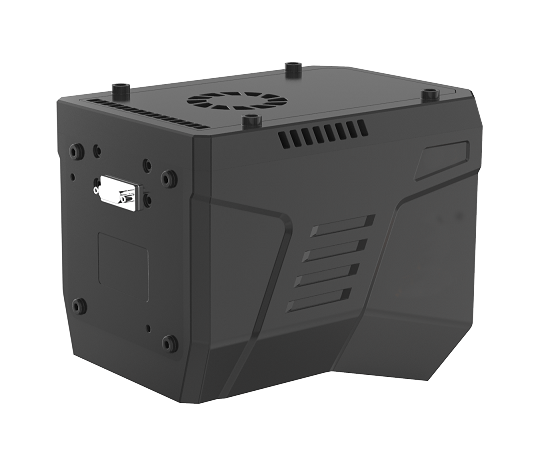
The MT-HEX is an airborne laser scanner specifically designed for corridor mapping, weighing only approximately 1.8 kg. It can be flexibly integrated into various UAV platforms, and its open data interfaces support multi-sensor collaboration. With a maximum measurement range of 1,500 m (at 80% reflectivity), a repeatability of 5 mm @ 100 m, and a design supporting up to 7 target returns, the system offers strong vegetation penetration capability. A scan line rate of up to 600 lines per second (customizable to 900 lines/s), combined with a laser pulse repetition rate of 2,000 kHz, ensures dense point-cloud coverage. The system features a 60°cross-track field of view paired with 0, ±10°along-track continuous tilt scanning, enabling accurate capture of detailed three-dimensional features. It is particularly suitable for applications that demand high-quality vertical-surface information, such as power line inspection and forestry surveys.
Optical parameter
| Laser Class | Class 1 |
| Laser Wavelength | 1550 nm |
| Beam Divergence | 0.5 mrad |
| Measurement Range | 10 m~2520 m@80% |
| Laser Pulse Repetition Rate | 100 k ~ 2000 kHz |
| Field of View | 75° |
| Angular Measurement Resolution | 0.001° |
| Measurement Technique | Pulse-phase ranging |
| Scan Rate | 80~400 lines/sec |
Laser measurement
| Repeatability Precision | 3 mm@100m(1σ) |
| Max. Number of Targets Per Pulse | Up to 16 echoes |
| Echo Signal Intensity | 8bit (Radiation correction) |
Dimension
| Weight | Approx. 2.1 kg |
| Size | Length * width * height |
| 205*127*141 mm |
Working environment
| Operating Temperature Range | -20℃~ +50℃ |
| Storage Temperature Range | -20℃~ +50℃ |
| Light condition | Natural environment |
| Humidity | Non-condensing |
| Protection Class | IP64 |
Power source
| Power Supply Input Voltage | 24V DC(20 V to 32 V input range) |
| Power Consumption | Approx. 55W |
Data interface
| TCP/IP | Gigabit Ethernet |
| PPS Synchronization Signal | Falling Edge Valid (TTL Level) |
| GNSS Signal Reception | RX (TTL Level) |